


Equator Maps: Great Smoky Mountains National Park app for iPhone and iPad
Developer: International Mapping
First release : 11 Mar 2013
App size: 221.01 Mb
Equator Maps has developed a content rich outdoor recreation app to help outdoor enthusiasts explore Great Smoky Mountain National Park. The app contains several layers of map detail surrounded by a series of easy-to-use navigational tools and personal customization features to help make your outdoor experience more enjoyable and memorable.
The Great Smoky Mountains National Park is a UNESCO World Heritage Site that is located in the Southeastern part of the United States, along the ridge line of the Great Smoky Mountains and part of the Blue Ridge Mountains. Dedicated in 1940, Great Smoky Mountain National park encompasses over 850 square miles and has become America’s most visited Park. Planning a hike in Great Smoky Mountains National Park? Looking for an app to help you navigate all of the trails? Worried you will not have Wi-Fi access while out on the trail? Then this is the app for you as we have included everything you will need in the download!
Key Content Features:
+ Full content and detail for Great Smoky Mountain National Park, covering Mount Le Conte, Clingmans Dome, Fontana Lake, Cades Cove, Abrams Falls, The Sinks, Laurel Falls, Rainbow Falls, Charlies Bunion, and more!
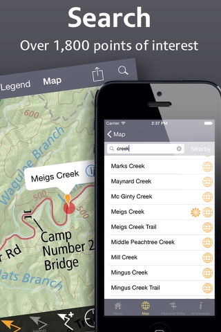
+ Point of Interest listings for over 1800 locations in and around the Great Smoky Mountain National Park area.
Key Features Include:
+ GPS tracking of your location, even without Wi-Fi or cell reception
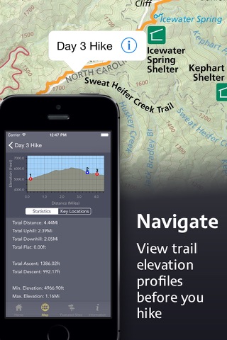
+ A revolutionary new trail navigation system
+ Dynamically generated trail elevation profiles
+ Map tools including distance, area, bearing and compass
+ Customized pins to record photos, comments, & Locations along your hike
+ Create and share your favorite pathways with photos and comments
+ Share your custom markers with others who have the app
+ Detailed search capabilities by nearby locations and by type
+ Identify the Latitude/Longitude or UTM Coordinate for any place on the map
Equator Maps: Great Smoky Mountain National Park was developed by International Mapping. To learn more visit: www.internationalmapping.com